University of Minnesota
http://www.umn.edu/
612-625-5000
http://www.umn.edu/
612-625-5000
Minnesota Biodiversity Atlas
Bell Museum
Dataset: MIN-Plants
Taxa: Crataegus chrysocarpa
Search Criteria: excluding cultivated/captive occurrences
Bell Museum plants | |
 MIN:Plants | 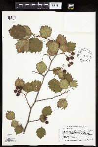 429052[1025501]Smith, Welby 268581997-09-15 United States, Minnesota, Crow Wing, Crow Wing County ... Crow Wing Sate Park, ca 7 miles N of Fort Ripley ... T44N R32W SW1/4 of SW1/4 of Sec 26;Crow Wing State Park;044N;32W;26, 46.2622222 -94.3425 |
MIN:Plants | 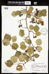 492625[1025680]Smith, Welby 268751997-09-22 United States, Minnesota, Lincoln, Lincoln County ... On the north side of Highway 14, about one mile west of its junction with Highway 75 in Lake Benton (town) ... T109N R45W NW1/4 of NE1/4 of Sec 7. 109N 45W 7, 44.2663889 -96.3077778 |
MIN:Plants | 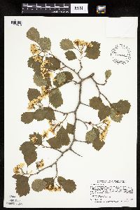 431988[1025819]Smith, Welby 265381997-05-27 United States, Minnesota, Washington, In the St. Croix Valley, about 1.5 miles north of Marine. SW1/4 of SW1/4 of Sec;William O'Brien State Park;032N;19W;30, 45.225 -92.76 |
MIN:Plants | 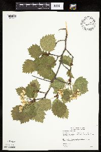 454899[1025609]Gerdes, Lynden 39542000-06-04 United States, Minnesota, Lake, Finland State Forest / North Shore. Lake County ... Near Ecbeck Forest Campground, Finland, MN ... North of the campground; west side of River and N of Hwy. 1 ... T57N R07W S33SESW. 057N 07W 33, 47.3789 -91.22489 |
MIN:Plants | 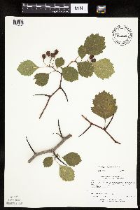 435084[1025694]Lee, Michael MDL19131997-08-13 United States, Minnesota, Stearns, Stearns County...5 miles south of Avon...T124N R30W SW1/4 SE1/4 NE1/4 Sec. 20;;124N;30W;20, 45.53605 -94.47374 |
MIN:Plants | 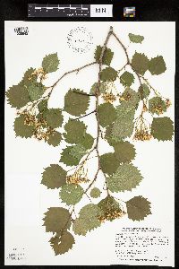 429043[1025842]Smith, Welby 278041999-05-27 United States, Minnesota, Red Lake, Red Lake County ... Along Hwy 92, about 2.5 miles east of Terrebonne ... along the 'river' ... T150N R42W SE1/4 of NE1/4 of Sec 7. 150N 42W 7, 47.8266667 -96.075 |
MIN:Plants | 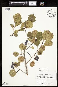 456527[1025679]Lee, Michael MDL19781997-09-30 United States, Minnesota, Stearns, Stearns County...2-1/2 miles SSE of Roscoe...T122N R31W NE1/4 of SE1/4 of Sec. 6;;122N;31W;06, 45.40486 -94.62413 |
MIN:Plants | 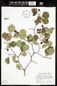 472010[1025765]Smith, Welby 275811998-09-08 United States, Minnesota, Stearns, About 3 miles SW of St. Cloud. NW1/4 of NW1/4 of Sec.;Quarry Park Nature Preserve & Scientific Natural Area;124N;28W;29, 45.5283333 -94.2352778 |
MIN:Plants | 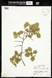 499699[1025706]Gerdes, Lynden; et al. 45292002-06-13 United States, Minnesota, Cook, Magnetic Rock Hiking Tail. Vicinity of the Gunflint Trail, Grand Marais.;Superior National Forest;065N;04W;22, 48.09865 -90.8257 |
MIN:Plants | 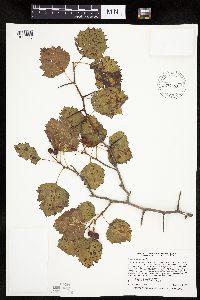 487867[1025846]Smith, Welby 259341995-09-04 United States, Minnesota, Steele, Steele County ... Rice Lake State Park, about 4 miles northwest of Claremont ... T 107N R 19W NW1/4 of NW1/4 of Sec 12;Rice Lake State Park;107N;19W;12, 44.0897222 -93.0647222 |
MIN:Plants | 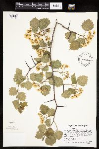 429233[1025740]Smith, Welby 256221995-05-28 United States, Minnesota, Scott, At the rest stop on south-bound I35 just north of the Scott-Rice county line ... NE1/4 SE1/4 of section.;;113N;21W;35, 44.546626 -93.300787 |
MIN:Plants | 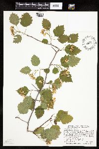 429283[1026434]Smith, Welby 278251999-05-28 United States, Minnesota, Beltrami, Beltrami County ... About 3 miles west of Fourtown ... T 155N R 37W NW1/4 of NW1/4 of Sec 3;;155N;37W;03, 48.2805556 -95.3994444 |
MIN:Plants | 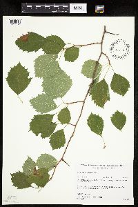 482178[1025671]Gerdes, Lynden; et al. 32061998-08-18 United States, Minnesota, Cook, Boundary Waters Canoe Area Wilderness / Superior National Forest. T65N R03E S27. Cook County; Superior National Forest, BWCAW. West end of portage between Moose Lake and North Fowl Lake. east end of Moose Lake/North Fowl Lake portage.. 065N 03E 27, 48.08538 -90.04696 |
MIN:Plants | 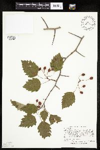 453093[1025760]Lee, Michael MDL27101999-09-16 United States, Minnesota, Lake, North Shore. Lake County...Superior Hiking Trail at 'Wolf Rock', overlooking the Crow Creek valley three miles west-southwest of Castle Danger...T54N R10W NE1/4 of SE1/4 of SE1/4 Sec. 35. 054N 10W 35, 47.12006 -91.56939 |
MIN:Plants | 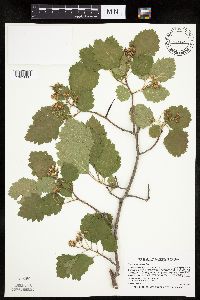 461972[1025600]Smith, Welby 265831997-06-06 United States, Minnesota, Big Stone, about 3.5 miles SE of Ortonville. SE1/4 of NE1/4 of Sec.;Big Stone National Wildlife Refuge;121N;46W;27, 45.2627778 -96.4113889 |
MIN:Plants | 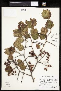 493683[1025683]Smith, Welby 259401995-09-04 United States, Minnesota, Dakota, Dodge County ... One mile south of Eagen corporate boundary, on the west side of Highway 3 (South Robert Trail) at jct with 130th St ... T115N R19W NW1/4 of NE1/4 of Sec 20. T115N R19W S20, 44.753635 -93.126005 |
MIN:Plants | 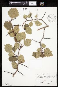 917049[1025639]Lee, Michael MDL15381996-09-05 United States, Minnesota, Saint Louis, Kabetogama State Forest. St. Louis County...On the northwest shore of Pelican Lake at the public water access. Seven miles west of Orr...T65N R21W SE1/4 SE1/4 NW1/4 Sec. 36. 065N 21W 36, 48.07449 -92.97755 |
MIN:Plants | 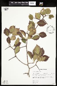 476791[1025667]Gerdes, Lynden 33481998-09-10 United States, Minnesota, Lake, Superior National Forest. Lake County ... Superior National Forest. Northern wetland edge of Climber Lake; just south of the Tomakawk Road/August Lake road junction ... T61N R10W S28SESW. 061N 10W 28, 47.74049 -91.6086 |
MIN:Plants | 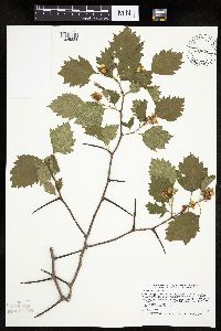 429133[1025834]Smith, Welby 266151997-06-13 United States, Minnesota, Saint Louis, St. Louis County ... along the Shannon River about 2 mi northeast of Shannon Lake ... T60N R21W SE1/4 of NE1/4 of Sec 25;Sturgeon River State Forest;060N;21W;25, 47.6541667 -92.9341667 |
MIN:Plants | 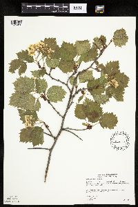 476736[1025856]Gerdes, Lynden 39512000-07-04 United States, Minnesota, Lake, Finland State Forest / North Shore. T57N R07W S33SESW. Lake County ... Near Ecbeck Forest Campground, Finland, MN. North of the campground; west side of River and N. of Hwy. 1.. 057N 07W 33, 47.3789 -91.22489 |
MIN:Plants | 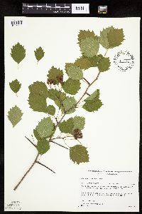 482176[1025669]Gerdes, Lynden; et al. 27181998-06-17 United States, Minnesota, Cook, Superior National Forest. T65N R04W S27SWSW. Cook County; Superior National Forest. Cross River area east of the Round Lake Rd (Cty. 47) and approx. 0.3 miles south of the Gunflint Trail (Cty. 12). 065N 04W 27, 48.08424 -90.82544 |
MIN:Plants | 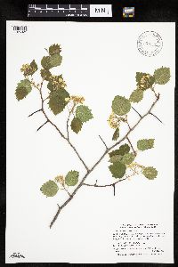 905122[1025821]Smith, Welby; et al. 293692003-05-16 United States, Minnesota, Wadena, Wadena County...On the dick Oehlenschlager farm, about 3 miles SE of Nimrod...T136N R33W NW1/4 of NW1/4 of Sec 11;;136N;33W;11, 46.6138889 -94.8177778 |
MIN:Plants | 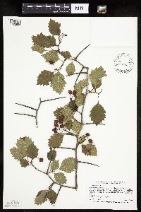 453346[1025824]Smith, Welby 268311997-09-03 United States, Minnesota, Lake, Lake County ... Where Highway 1 crosses the Baptism River ... T57N R7W SE1/4 of SW1/4 of Sec 33;Finland State Forest / North Shore;057N;07W;33, 47.3738889 -91.2297222 |
MIN:Plants | 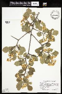 427023[1025828]Smith, Welby 265451997-05-29 United States, Minnesota, Meeker, Meeker County ... between Highway 7 and the old Chicago & Northwestern Railroad tracks ... about 1.5 miles east of Corvuso ... T117N R31W NE1/4 of SW1/4 of Sec 16. 117N 31W 16, 44.9411111 -94.5744444 |
MIN:Plants | 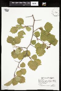 490513[1025836]Smith, Welby 272391998-06-10 United States, Minnesota, Waseca, Saint Olaf Lake County Park. Waseca County ... St. Olaf Lake, in St. Olaf Lake County Park, about 4 miles east of New Richland ... T 105N R 22W NW1/4 of NE1/4 of Sec 13. 105N 22W 13, 43.9047222 -93.4147222 |
MIN:Plants | 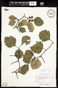 435090[1025695]Lee, Michael MDL19561997-09-17 United States, Minnesota, Stearns, Stearns County...In the city limits on the southeast side of Waite Park...T124N R28W NW1/4 SW1/4 NE1/4 Sec. 31;;124N;28W;31, 45.50832 -94.25012 |
MIN:Plants | 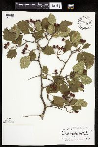 453495[1025734]Smith, Welby 268301997-09-03 United States, Minnesota, Lake, Lake County ... Where Highway 1 croses the Baptism River ... T57N R7W SE1/4 of SW1/4 of Sec 33;Finland State Forest / North Shore;057N;07W;33, 47.3738889 -91.2297222 |
MIN:Plants | 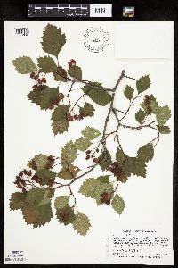 462143[1025495]Smith, Welby 268281997-09-03 United States, Minnesota, Saint Louis, St. Louis County ... On the south side of Highway 61, about 2 miles SW of the Lake-St. Louis county line ... T51N etc.;North Shore;051N;12W;02, 46.93 -91.8305556 |
MIN:Plants | 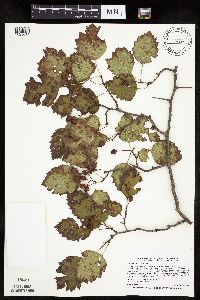 454957[1025632]Smith, Welby 268411997-09-10 United States, Minnesota, Washington, in the St. Croix Valley about 1.5 miles north of Marine. SW1/4 of SW1/4 of Sec.;William O'Brien State Park;032N;19W;30, 45.225 -92.76 |
MIN:Plants | 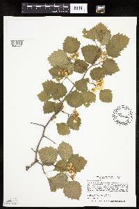 455532[1025657]Smith, Welby 256411995-06-01 United States, Minnesota, Steele, About 4 miles northwest of Claremont. NW1/4 of NW1/4 of section;Rice Lake State Park;107N;19W;12, 44.0897222 -93.0647222 |
MIN:Plants | 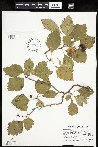 461915[1025552]Smith, Welby 268771997-09-22 United States, Minnesota, Big Stone, Big Stone National Wildlife Refuge. Big Stone County ... Big Stone National Wildlife Refuge, about 3.5 miles SE of Ortonville ... T121N R46W SE1/4 of NE 1/4 of Sec 27. 121N 46W 27, 45.2627778 -96.4113889 |
MIN:Plants | 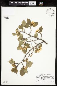 505604[1025869]Smith, Welby 265361997-05-27 United States, Minnesota, Washington, Saint Croix National Riverway. Washington County ... In the St. Croix Valley, about 2 miles northeast of Stillwater ... west side of Highway 95 ... T30N R20W NW1/4 of SE1/4 of Sec 10. 030N 20W 10, 45.0977778 -92.7877778 |
MIN:Plants | 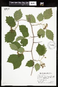 905463[1025700]Smith, Welby 294552004-06-03 United States, Minnesota, Ramsey, Ramsey County...In Poplar Lake County Park...T 30N R 23W SE1/4 of NE1/4 of Sec 1;Poplar Lake County Park;030N;23W;01, 45.1191667 -93.1105556 |
MIN:Plants | 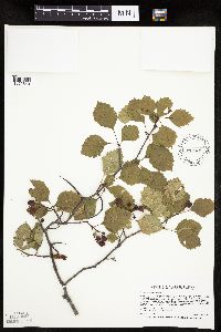 431945[1025840]Smith, Welby 268461997-09-14 United States, Minnesota, Saint Louis, St. Louis County ... About 4 miles northwest of Chisholm ... T59N R21W SW1/4 of SW1/4 of Sec 36;;059N;21W;36, 47.5463905 -92.9547195 |
MIN:Plants | 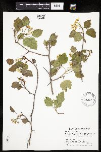 905348[1025635]Smith, Welby; et al. 29363A2003-05-16 United States, Minnesota, Wadena, Wadena County ... About 4 miles southeast of Sebeka ... T136N R34W NW 1/4 of NE1/4 of Sec 18;;136N;34W;18, 46.59377 -95.02037 |
MIN:Plants | 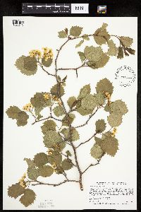 429271[1025613]Smith, Welby 265531997-05-29 United States, Minnesota, Lac Qui Parle, Lac Qui Parle Wildlife Management Area. Lac Qui Parle County ... Lac Qui Parle State Wildlife Management Area, about 5 miles south of Milan ... T118N R42W SE1/4 of SW1/4 of Sec 10. 118N 42W 10, 45.0408325 -95.9119415 |
MIN:Plants | 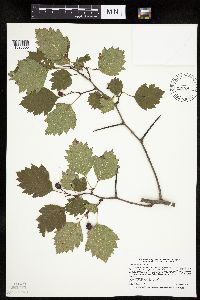 429129[1025835]Smith, Welby 268481997-06-13 United States, Minnesota, Saint Louis, St. Louis County ... along the Shannon River about 2 mi northeast of Shannon Lake ... T60N R21W SE1/4 of NE1/4 of Sec 25;Sturgeon River State Forest;060N;21W;25, 47.6541672 -92.934166 |
MIN:Plants | 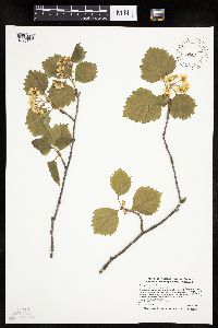 489278[1025790]Smith, Welby 270431998-05-12 United States, Minnesota, Koochiching, Koochiching State Forest. Koochiching County ... Just north of where County Road 5 crosses the Big Fork River at Craigville ... T 63N R 26W SE1/4 of NW1/4 of Sec 36. 063N 26W 36, 47.9069443 -93.6108322 |
MIN:Plants | 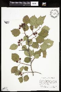 427020[1025795]Smith, Welby 254791994-09-08 United States, Minnesota, Itasca, At bowstring lodge; on the north side of Bowstring Lake. SW1/4 of SW1/4 of section;Chippewa National Forest;147N;25W;06, 47.5716667 -93.9030556 |
MIN:Plants | 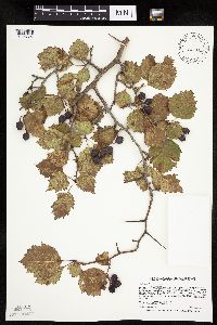 540958[1025627]Smith, Welby 268811997-09-23 United States, Minnesota, Lac Qui Parle, Lac Qui Parle Wildlife Management Area. Lac Qui Parle County ... Lac Qui Parle Wildlife Management Area, about 5 miles south of Milan ... T118N R42W SE1/4 of SW1/4 of Sec 10. 118N 42W 10, 45.0408325 -95.9119415 |
MIN:Plants | 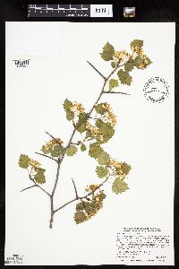 462221[1025607]Smith, Welby 278241999-05-28 United States, Minnesota, Beltrami, Beltrami County ... About 3 miles west of Fourtown ... T 155N R 37W NW1/4 of NW1/4 of Sec 3;;155N;37W;03, 48.2805557 -95.3994446 |
MIN:Plants | 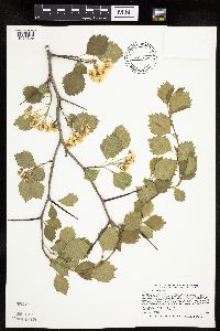 455582[1025799]Smith, Welby 265861997-06-08 United States, Minnesota, Carlton, Carlton County ... About 200 meters E of where the Willard Munger Trail crosses the St. Louis R, one mile E of Carlton ... T48N R16W SW1/4 of SW1/4 of Sec 5. 048N 16W 5, 46.6633339 -92.4036102 |
MIN:Plants | 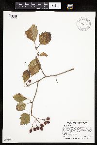 914163[1025750]Smith, Welby 254821994-09-08 United States, Minnesota, Polk, At Nancy Sather's farm, about 1.25 miles west of the Polk-Clearwater county line. NE1/4 of SE1/4 of Section;;147N;39W;11, 47.5633333 -95.5802778 |
MIN:Plants | 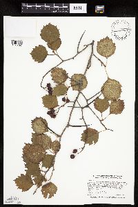 226046[1025797]Smith, Welby 275721998-09-03 United States, Minnesota, Cass, On the north side of the Crow Wing River, about 4 miles E-SE of Pilager. SE1/4 of SE1/4 of section;;133N;30W;24, 46.3158333 -94.3908333 |
MIN:Plants | 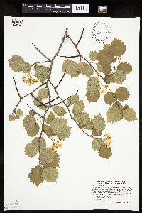 462345[1025648]Smith, Welby 270211998-05-11 United States, Minnesota, Cass, On the north side of the Crow Wing River, about 4 miles E-SE of Pillager. SE1/4 of SE1/4 of section;;133N;30W;24, 46.3158333 -94.3908333 |
MIN:Plants | 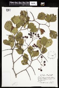 488063[1025742]Smith, Welby 275511998-08-20 United States, Minnesota, Itasca, Chippewa National Forest. Itasca County ... About 3 miles south of Northome, at the northwest end of Island Lake ... T 150N R 28W SW1/4 of SW1/4 of Sec 5. 150N 28W 5, 47.831665 -94.2624969 |
MIN:Plants | 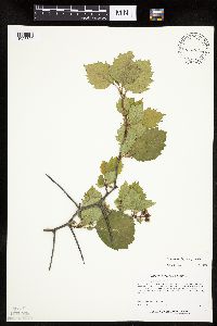 426787[1025829]Lee, Michael MDL17231997-06-12 United States, Minnesota, Stearns, Stearns County...4 miles south of St. Stephen...outcrop...T125N T29W SE1/4 SE1/4 Sec. 12;;125N;29W;12, 45.65196 -94.27407 |
MIN:Plants | 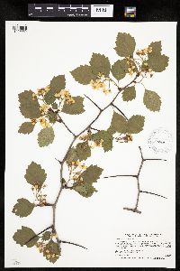 588232[1025562]Smith, Welby 266271997-06-18 United States, Minnesota, Lake, Lake County...Where Highwy 1 crosses the Baptism River...T57N R7W SE1/4 of SW1/4 of Sec 33;Finland State Forest / North Shore;057N;07W;33, 47.3738889 -91.2297222 |
MIN:Plants | 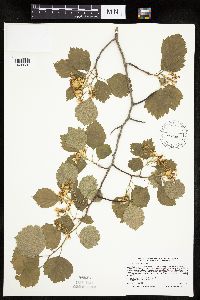 489569[1025536]Smith, Welby 265971997-06-09 United States, Minnesota, Cass, Cass County ... About 0.25 mile north of Highway 210 on Pillsbury Road, one mile northeast of Pillager ...T133N R30W SE1/4 of NE1/4 of Sec 16. 133N 30W 16, 46.3375015 -94.4516678 |
MIN:Plants | 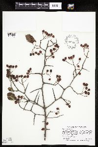 429095[1025766]Smith, Welby 268501997-09-14 United States, Minnesota, Saint Louis, Superior National Forest. St. Louis County ... west bank of the Shannon River, about 9 miles northwest of Chisholm ... T59N R21W SE1/4 of SW1/4 of Sec 2. 059N 21W 2, 47.6172218 -92.9694443 |
MIN:Plants | 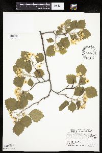 456142[1025511]Smith, Welby 277841999-05-23 United States, Minnesota, Aitkin, Savanna State Forest. Aitkin County ... Along the Mississippi River near the jct of Hwys 65 and 200; about 15 miles east of Hill City ... T 52N R 23W SE1/4 of SE1/4 of sec 9. 052N 23W 3, 47.0013885 -93.2694473 |
MIN:Plants | 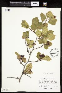 435082[1025696]Lee, Michael MDL19301997-09-03 United States, Minnesota, Stearns, 1-3/4 miles east of Cold Spring along Hwy 23. SE1/4 NW1/4 SE1/4 of section;Cold Spring Heron Colony Scientific Natural Area;123N;30W;13, 45.46397 -94.39432 |
MIN:Plants | 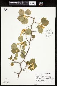 492672[1025867]Smith, Welby 265661997-06-02 United States, Minnesota, Lincoln, Lincoln County ... On the north side of Highway 14, about one mile west of its junction with Highway 75 in Lake Benton (town) ... T109N R45W NW1/4 of NE1/4 of Sec 7. 109N 45W 7, 44.2663879 -96.3077774 |
MIN:Plants | 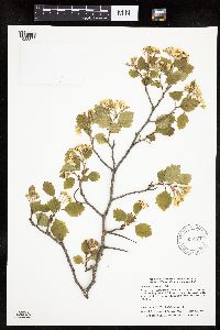 905129[1025822]Smith, Welby; Phipps, J. 293682003-05-16 United States, Minnesota, Wadena, About 4 miles southeast of Sabeka [sic]. NE1/4 of NW1/4 of section;;136N;34W;18, 46.593773 -95.0203652 |
MIN:Plants | 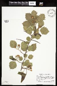 439023[1025827]Smith, Welby 266121997-06-13 United States, Minnesota, Saint Louis, St. Louis County ... About 6 miles northwest of Chisholm ... T59N R21W SW1/4 of SW1/4 of Sec 23;;059N;21W;23, 47.5730553 -92.9727783 |
MIN:Plants | 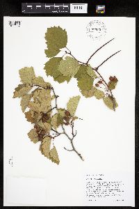 899955[1025509]Scott, P. 18802004-08-27 United States, Minnesota, Cook, COOK CO. ... By Magnetic Rock Tr. T65N R4W sec.22 NWSESE;Superior National Forest;065N;04W;22, 48.09865 -90.8257 |
MIN:Plants | 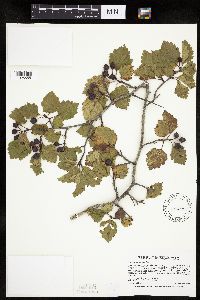 145559[1025555]Smith, Welby 268601997-09-15 United States, Minnesota, Crow Wing, Crow Wing State Park. Crow Wing County ... Crow Wing State Park, ca 7 miles N of Fort Ripley ... On floodplain but above floodway ... T44N R32W SW1/4 of SW1/4 of Sec 26. 044N 32W 26, 46.2622222 -94.3425 |
MIN:Plants | 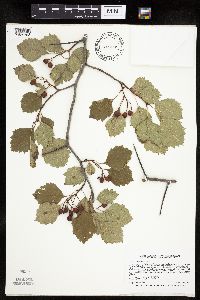 429058[1025798]Smith, Welby 268381997-09-09 United States, Minnesota, Carlton, Carlton County ... About 200 meters E of where the Willard Munger Trail crosses the St. Louis R, one mile E of Carlton ... T48N R16W SW1/4 of SW1/4 of Sec 5. 048N 16W 5, 46.6633339 -92.4036102 |
MIN:Plants | 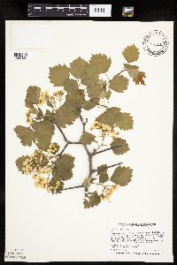 475163[1025826]Smith, Welby 256241995-05-28 United States, Minnesota, Dakota, One mile south of Eagen [sic] corporate boundary, on the west side of Highway 3 (South Robert Trail) at jct with 130th St. NW1/4 of NE1/4 of section;;115N;19W;20, 44.7605553 -93.1230544 |
MIN:Plants | 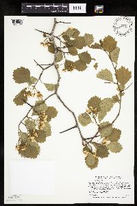 429246[1025611]Smith, Welby 26558 United States, Minnesota, Fillmore, Beaver Creek Wildlife Management Area. Fillmore County ... Beaver Creek State Wildlife Management Area, about 5 miles east-northeast of LeRoy ...T101N R13W NW1/4 of SW1/4 of Sec 21. 101N 13W 21, 43.5344444 -92.4047222 |
MIN:Plants | 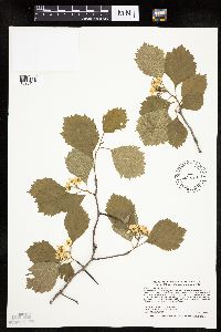 490551[1025744]Smith, Welby 277531999-05-17 United States, Minnesota, Fillmore, Fillmore County ... Goethite State Wildlife Management Area, about 3 miles east of Ostrander ... T 102N R 13W etc.;Goethite Wildlife Management Area;102N;13W;23, 43.61356 -92.367931 |
MIN:Plants | 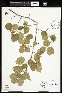 429094[1025832]Smith, Welby 265951997-06-09 United States, Minnesota, Crow Wing, Crow Wing County ... Crow Wing State Park, ca 7 miles N of Fort Ripley ... T44N R32W SW1/4 of SW1/4 of Sec 26;Crow Wing State Park;044N;32W;26, 46.2622223 -94.3424988 |
MIN:Plants | 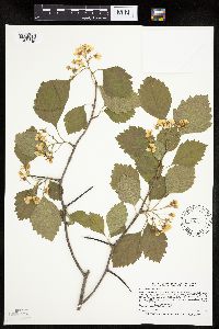 489415[1025746]Smith, Welby 265891997-06-08 United States, Minnesota, Carlton, Carlton County ... Moose Lake State Park, about 5 miles south-southwest of Barnum ... T46N R19W SW1/4 of SE1/4 of Sec 27;Moose Lake State Park;046N;19W;27, 46.4355545 -92.7313919 |
MIN:Plants | 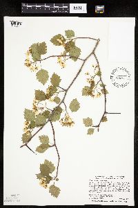 429287[1025614]Smith, Welby 277781999-05-23 United States, Minnesota, Cass, Cass County ... On the north side of Hwy 7, about 3 miles east of Longville ... T 141N R 27W SE1/4 of SE1/4 of Sec 31;Chippewa National Forest / Leech Lake Indian Reservation;141N;27W;31, 46.9777794 -94.1363907 |
MIN:Plants | 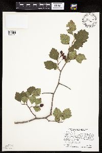 475153[1025794]Smith, Welby 259361995-09-04 United States, Minnesota, Dodge, Dodge County ... Dodge Center Creek City Park, ca 1 mile NW of Dodge Center ... T 107N R 17W SW1/4 of SW1/4 of Sec 28;;107N;17W;28, 44.040554 -92.8780518 |
MIN:Plants | 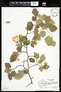 429048[1025767]Smith, Welby 266131997-06-13 United States, Minnesota, Saint Louis, Superior National Forest. St. Louis County ... west bank of the Shannon River, about 9 miles northwest of Chisholm ... T59N R21W SE1/4 of SW1/4 of Sec 2. 059N 21W 2, 47.6172218 -92.9694443 |
MIN:Plants | 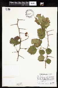 475155[1025733]Smith, Welby 259311995-09-04 United States, Minnesota, Steele, Steele County ... At south-bound I35 rest stop on the Straight River, about 8 miles south of Owatonna ... T 106N R 20W NE1/4 of SW1/4 of sec 17. 106N 20W 17, 43.9852791 -93.2574997 |
MIN:Plants | 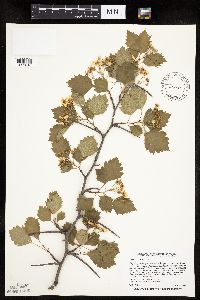 462231[1025816]Smith, Welby 256251995-05-28 United States, Minnesota, Dakota, One mile south of Eagen [sic] corporate boundary, on the west side of Highway 3 (South Robert Trail) at jct with 130th St. NW1/4 of NE1/4 of section;;115N;19W;20, 44.7605556 -93.1230556 |
MIN:Plants | 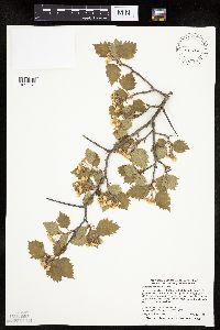 488332[1025747]Smith, Welby 277881999-05-23 United States, Minnesota, Aitkin, Aitkin County ... On Hwy 232, about 1.5 miles east of Palisade ... T 49N R 25W SE1/4 of SW1/4 of Sec 24;;049N;25W;24, 46.710556 -93.4538879 |
MIN:Plants | 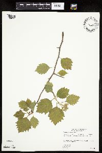 477606[1025780]Gerdes, Lynden 39262000-05-30 United States, Minnesota, Lake, Lake County ... Tettegouche State Park. North shore of Baptism River and NW of Hwy. 61 ...T56N R07W S15NWNE;North Shore / Tettegouche State Park;056N;07W;15, 47.33679 -91.20911 |
MIN:Plants | 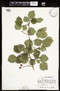 462091[1025514]Smith, Welby 259301995-09-04 United States, Minnesota, Steele, Steele County ... At south-bound I35 rest stop on the Straight River, about 8 miles south of Owatonna ... T 106N R 20W NE1/4 of SW1/4 of Sec 17. 106N 20W 17, 43.9863892 -93.2522202 |
MIN:Plants | 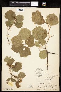 126772[1025624]Rosendahl, C. 25751912-05-30 United States, Minnesota, Washington, Gray Cloud Island in Mississippi River.;;;;, 44.8086 -92.9944 |
MIN:Plants | 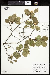 462180[1025553]Smith, Welby 266101997-06-12 United States, Minnesota, Lake, Lake County ... Stony River, about 50 meters west of where it crosses Highway 1 ... T60N R10W NE1/4 of NE1/4 of Sec 28;Superior National Forest;060N;10W;28, 47.6591667 -91.6019444 |
MIN:Plants | 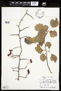 462092[1025508]Smith, Welby 259291995-09-02 United States, Minnesota, Wright, Wright County ... abandoned railroad embankment on the north side of I94, 1.7 miles E-SE of Hasty ... T 122N R 26W NW1/4 of SE1/4 of Sec 22. T122N R26W S22, 45.362268 -93.942405 |
MIN:Plants | 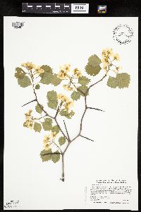 472004[1025497]Smith, Welby 270081998-05-08 United States, Minnesota, Stearns, About 3 miles SW of St. Cloud. NW1/4 of NW1/4 of Sec.;Quarry Park Nature Preserve & Scientific Natural Area;124N;28W;29, 45.5283318 -94.2352753 |
MIN:Plants | 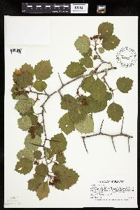 429239[1025612]Smith, Welby 266531997-06-26 United States, Minnesota, Pope, Pope County ... Glacial Lakes State Park. On the east side of Signal Lake, about 5 miles south of Starbuck ... T124N etc;Glacial Lakes State Park;124N;39W;24, 45.5413895 -95.5219421 |
MIN:Plants | 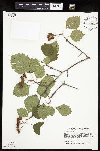 475150[1025791]Smith, Welby 273791998-07-10 United States, Minnesota, Otter Tail, Bluff Creek Wildlife Management Area. Otter Tail County ... Bluff Creek State Wildlife Management Area, about 11 miles west of Sebeka ... T 136N R 37W NE1/4 of NW1/4 of Sec 2. 136N 37W 2, 46.6286125 -95.3144455 |
MIN:Plants | 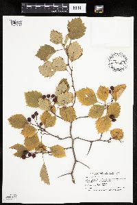 173037[1025796]Smith, Welby 254331994-09-07 United States, Minnesota, Koochiching, About 18 miles west of International Falls. On the bank of the Rainy River. NW1/4 of NE1/4 of section;Grand Mound Historical Site;070N;26W;32, 48.5158333 -93.7083333 |
MIN:Plants | 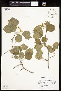 429020[1025841]Smith, Welby 256311995-05-29 United States, Minnesota, Steele, At the south-bound I35 rest stop on the Straight River, about 8 miles south of Owatonna. NE1/4 of SW1/4 of section;;106N;20W;17, 43.9852778 -93.2575 |
MIN:Plants | 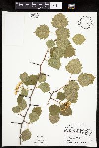 462197[1025633]Smith, Welby 256441995-06-03 United States, Minnesota, Wright, about 3 miles SW of Cokato. NE1/4 of SW1/4 of Sec.;Collinwood County Park;118N;28W;07, 45.0422222 -94.265 |
MIN:Plants | 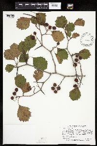 145349[1025602]Smith, Welby 268701997-09-19 United States, Minnesota, Fillmore, about 5 miles east-northeast of LeRoy. NW1/4 of SW1/4 of Sec.;Beaver Creek Wildlife Management Area;101N;13W;21, 43.5344444 -92.4047222 |
MIN:Plants | 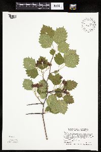 439065[1025689]Smith, Welby 272631998-06-17 United States, Minnesota, Cook, Boundary Waters Canoe Area Wilderness / Superior National Forest. Cook County ... In the Boundary Waters Canoe Area Wilderness, Superior National Forest ... T65N R4W SW1/4 of SE1/4 of Sec 27. 065N 04W 27, 48.0802765 -90.7380524 |
MIN:Plants | 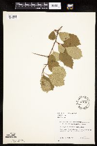 553664[1025610]Mielke, Walter 1281958-06-23 United States, Minnesota, Itasca, Across the road from the Trout Lake Concentrator.;;;;, 47.45131 -93.54584 |
MIN:Plants | 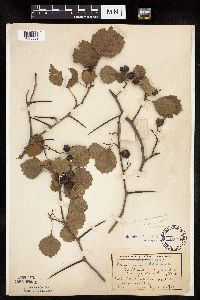 126410[1025852]Wheeler, William 11701901-09-26 United States, Minnesota, Ramsey, Cleveland Ave. N of S of Agri. [Univ. of Minnesota campus] St. Anthony Park;;029N;23W;, 44.99208 -93.16639 |
MIN:Plants | 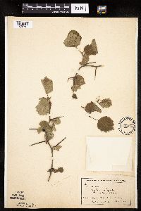 126411[1025712]Wheeler, William 10001901-09-06 United States, Minnesota, Hennepin, Washburn Park;;;;, 44.9108 -93.284 |
MIN:Plants | 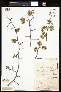 126412[1025605]Wheeler, William 1521H1901-05-11 United States, Minnesota, Hennepin, Near Washburn Park, Henn. Co.;;;;, 44.910767 -93.284014 |
MIN:Plants | 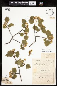 126414[1025515]Wheeler, William 10011901-05-11 United States, Minnesota, Hennepin, Near Washburn Park, Hennepin Co..;;;;, 44.9108 -93.284 |
MIN:Plants | 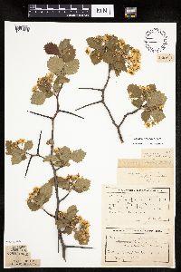 126419[1025547]Wheeler, William 10031901-05-11 United States, Minnesota, Hennepin, Ft Snelling Reserv. near Minnehaha;Fort Snelling Military Reservation;028N;23W;20, 44.8976042 -93.1987137 |
MIN:Plants | 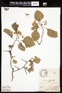 126765[1025604]Sandberg, J. H. s.n.1886-05-00 United States, Minnesota, Goodhue, Red Wing;;113N;14W;00, 44.55522 -92.49554 |
MIN:Plants | 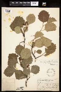 126766[1025525]Rosendahl, C. 25801912-06-04 United States, Minnesota, Hennepin, 1-1/2 mi west of Cedar Lake, Minneapolis;;029N;24W;00, 44.99193 -93.28815 |
MIN:Plants | 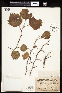 126900[1025569]Wheeler, William 11431901-09-14 United States, Minnesota, Rock, near Mound Creek, Luverne;;102N;45W;, 43.63087 -96.23268 |
MIN:Plants | 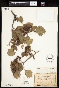 126903[1025710]Wheeler, William 11631901-09-17 United States, Minnesota, Rock, On the "Mound". Luverne;Blue Mounds State Park;102N;45W;, 43.63087 -96.23268 |
MIN:Plants | 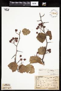 126904[1025538]Wheeler, William 11441901-09-14 United States, Minnesota, Rock, On "Mound" at Mound Creek, Luverne.;Blue Mounds State Park;102N;45W;00, 43.63087 -96.23268 |
MIN:Plants | 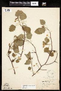 127041[1025805]Rosendahl, C. 24941913-05-30 United States, Minnesota, Ramsey, St. Anthony Park, St. Paul;;029N;23W;00, 44.99208 -93.16639 |
MIN:Plants | 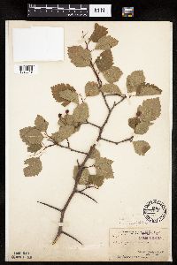 127060[1025519]Arthur, J.; et al. B571886-07-19 United States, Minnesota, Saint Louis, Vermilion Lake;;;;, 47.89167 -92.36667 |
MIN:Plants | 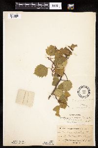 127061[1025664]Sheldon, Edmund S14972000-08-00 United States, Minnesota, Lincoln, Lake Benton;;109N;45W;00, 44.24108 -96.26172 |
MIN:Plants | 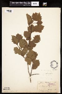 127062[1025853]Arthur, J.; et al. B4491886-07-28 United States, Minnesota, Saint Louis, Mud Lake, Vermilion Lake;;062N;14W;03, 47.88109 -92.10443 |
MIN:Plants | 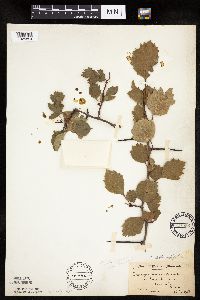 127063[1025854]Moyer, Lycurgus s.n.1908-08-16 United States, Minnesota, Lincoln, Lake Shore, State Line;;N;;, 44.48965 -96.45035 |
MIN:Plants | 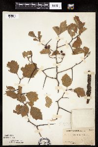 127064[1025851]Moyer, Lycurgus 1999A1903-08-19 United States, Minnesota, Big Stone, Chamberlain's Island, Big Stone Lake;;N;;, 45.40134 -96.64948 |
MIN:Plants | 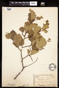 127066[1025757]MacMillan, C.; et al. 2811900-08-00 United States, Minnesota, Polk, Crookston;;150N;46W;30, 47.782 -96.60007 |
Google Map
Google Maps is a web mapping service provided by Google that features a map that users can pan (by dragging the mouse) and zoom (by using the mouse wheel). Collection points are displayed as colored markers that when clicked on, displays the full information for that collection. When multiple species are queried (separated by semi-colons), different colored markers denote each individual species.